Showing posts with label Reno. Show all posts

Thursday, May 4, 2023

A Small Unsigned Painting by William Vaughn Howard

William Vaughn Howard
Unsigned
acrylic, graphite and pastel
3 5/8 x 22 1/2 inches


This painting was given to me by my painting professor William Vaughn Howard. I studied with him as an undergraduate at the University of Nevada, Reno in the early 80s. Unsigned, I imagine that it was painted not long before he died in 1986.


The sweeping span feels like taking in a vista, a view given to the arc of the horizon, where the implication of distance is what seeing is all about. Having nothing to focus on, movement is a wonderment that extends well beyond the singularity of a moment associated with the composed. Not bounded by a fixed position, you are free to examine the painting as you will. I had never seen anything like this before.  The paintings in Bill's last show were a revelation to me. In the form of abstraction, he tackled the act of seeing, which involves a lot more than composing pictures that replicate arrangements based on paintings from the past. When the contours of design were being considered, landscape painting wasn't in the picture. Painting wasn't about navigating the fields or getting around town. It was about literature. Artists were painting stories that couldn't be observed. No one had seen Adam and Eve consume the forbidden fruit. Composition was a creation that made it possible to portray events that couldn't be observed. There is no need to create a stage to observe the observable. Bill's paintings capture events of seeing. Seeing is primarily about navigating life. It doesn't have to be about manufacturing hierarchies. William Vaughn Howard's paintings made it possible for me to freely paint my surroundings without having to worry about how things should be taken in. His paintings eliminated the need for a stage. Landscape painting no longer needed to conform to the compositional huddle that never considered the breadth of earth and sky when it was being devised as a way to describe the unseen events of literature. With the elimination of focus, landscape painting could finally express the ramifications of space.

Sunday, November 11, 2018

Voran Realty Co., Post Office, and City Park, Belpre, Kansas, US Highway 50

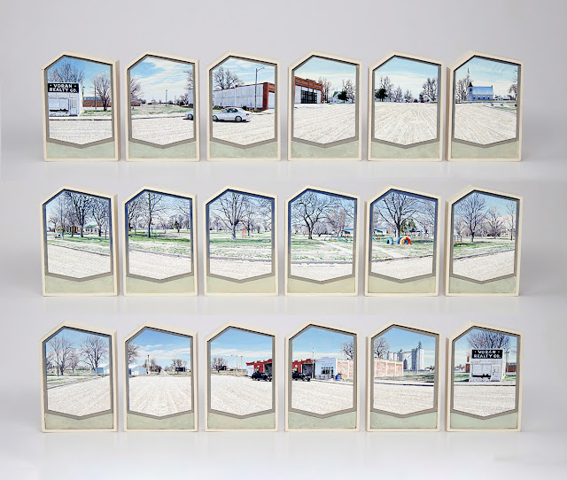
Voran Realty Co., Post Office, and City Park, Belpre, Kansas, US Highway 50, 2016, acrylic on 18 shaped ragboard panels, artist-made frames, 8  1/4 x 120 x 2 3/4 inches, Private Collection. Courtesy of Valley House Gallery

Perhaps, Belpre can best be described as a small town around 20 miles east of Kinsley, Kansas. That in and of itself is not much of a description, but since I’ve driven the highway, I know that Kinsley, Kansas is Midway U.S.A. There is a sign there with arrows pointing in opposite directions to New York and San Francisco. From that location, it is 1561 miles to either city. There is a roadside park with a black steam locomotive, picnic tables, and a small museum. I considered the mileage posted on the large painted arrows and without much thought decided to remain on the open plains for a little while longer.

As a proponent of the long view, I drove the length of the nation and saw only a few sites that could be described with a single snapshot. Without at least two consecutive views, it is hard to capture the idea of place. If you only shoot the barn, you have no field to tie the structure to the horizon. If you shoot only the field, there is no element to measure the distance between weeds stranded in clods of dirt and the sky. Without a sense of place, an image no matter how beautiful it may be is always a bit of an abstraction.

When I pulled into downtown Belpre, the first thing I saw was the abandoned real estate building. Looking at the surroundings, it was not difficult to see that business had been rough. The streets had been reduced to a covering of sandy gravel and commerce was limited to the US Post Office and another building that may have been a bar. On the other side of the street, there was a park with a painted playground in a field of trees that pretty much concealed the water tower. From that spot, there were also views of grain elevators, a steel building, a rutted country road, houses, a church, a building with no identifiable store front, and the possibility of an apartment building. I had come to capture the American scene; everywhere I looked it surrounded me, there was nothing to do but shoot everything I could see. Because of the height of the trees, I shot the expanse with the camera held vertically. I frequently go long, and there is always the option to shoot a 360 degree view of any location, but rarely is it imperative to capture the essence of a place. I’ve always liked parks and cemeteries. Often, they are the only visible things holding a town together. Once they go, a town is bound to be nothing more than crumbling rubble along a highway.

My father liked to camp and travel. As a child, I was only interested in mountains. The habitation of in-between places bored me. When I moved to Dallas after college, I was a long way from Saturday drives up into canyons. In the isolation of the big city on the plains, there was no way for me to connect to the nature I loved without several days of vacation. I had to learn to see other things. That separation from the mountainous West was the best thing to ever happen to me. In the absence of what can easily be identified as nature, I began to see cracks in the sidewalk and sky. Nature went from being the scent of tall pines on a mountainside to the idea of being there. As long as you are still living, you can connect, and that connection may be the storefronts of a shopping center, a barn, or vacated real estate building 20 miles east of Kinsley, Kansas. The moment was the thing I learned to really see and appreciate.

In 2005, I began painting the Nevada section of US Highway 50 known as the Loneliest Road in America. It was a familiar highway; my parents divorced when I was a child; 500 miles of mountains and valleys separated them. School years were spent living in rural Utah with my mother. Summertime took us to Reno, Nevada to live with my father. With the exception of a couple of years, I’ve been painting the highway ever since 2005. I expanded the survey in 2014 to include the entirety of the highway from Maryland to California. A vast project, it is not something that can be completed in a single season. It will likely require the rest of my life. I like the idea of covering the breadth of the nation from the vantage point of a single highway. A theme without limitations, I see the highway as a kind of a clothesline to hang innovation on.

When I moved to Dallas in 1983, I took a job as a picture framer. It is a skill every artist should have given that it is a large part of the material cost of making art. Over the years, I’ve done some innovative framing, but it would be a mistake to think it was driven by the frame shop experience. I started painting when I was ten and was pretty confident in my ability, but I didn’t realize that I was creative until I hit college. I had become disenchanted with landscape painting and latched onto abstraction. That is the thing that saved painting for me. Being able to respond directly to what was happening on the canvas taught me that anything was possible. If anything was possible, then any box could be rethought or imagined. In the embrace of abstraction, I acquired the thinking skills to remake the landscaping painting I grew up with as a child. I could learn to paint the moment which is what I did when I started making dioramas of my neighborhood in Richardson, Texas. Of course, it wasn’t that straightforward. It never is. As an artist, you can’t be standing at point A and look out into the distance at position B and think “that looks pretty nice, I think I will go over there” because the beautiful place called B doesn’t exist until you create it, and that can’t happen without a willingness to leave part of your identity behind. You can never realize who you really are by remaining in the same place. While you may have some ideas of where you want to go, vision is not about culmination.

An initial drawback of the diorama was that it was housed in the structure of a shadow box and a shadow box casts a lot of shadow. My solution to reduce unwanted shadow entailed parting ways with the structure of the frame. That meant that in the entire framing industry, there were no moldings that I could use. At that point, I would have been better off if I’d been a cabinet maker. If I’d been one, perhaps I could have imagined a better solution, but even so, the one I came up with hung nicely on the wall and changed the relationship between the art and the frame. The two were no longer separate things to me. The diorama made painting a kind of architecture, and although I no longer make dioramas, I continue to see painting that way.

Four years ago, I woke up one night with an image of a concaved surface that leaned forward in my mind. If it came from a dream, I don’t remember it. A few years earlier when I left framing, I replaced my table saw, scroll saw, chop saw and router with a plastic miter box and handsaw. Speed is not everything. It eliminated a lot of noise and I could work anywhere. Also, there was the added satisfaction of knowing that my hands were basically safe. The structure I imagined would have required a lot of the equipment that I’d gotten rid of. I decided that what I wanted to do could be done using ragboard. The solution was a typical one. I always seemed to find a way to innovate within the confines of the situation. Building the structure out of layered ragboard really was the best solution; acid free paper isn’t going to crack with age, as wood has the habit of doing.

Once a shape is imagined, others come to mind. Although I’d already painted a couple pieces with pitched rooflines, I wanted something that was asymmetrical. I covered the laptop monitor with a window cut out of cardstock and made adjustments to it until I found the right angles. I liked what I saw. The asymmetry felt more dramatic. The sensation was a little more like being outside. The view was less fixed or stable. It is all too easy to see a rectangle as a plane. Although no longer a rectangle, the shape was still a plane. The tilt forward forced a sense of direction into the flatness of the panel. Even though the positioning moved in the opposite direction of the perspective I was trying to illustrate, conceptually it was the right way to go. Perhaps that sounded a little confusing, but if you look at what I’ve done, you will see that the sky is literally closer to you than the gravel of the street. Although overhead sky can never be reached, in a sense it is very close to us. When walking down the street, we never see our feet, making the connection to earth more distant than the drift of sunlit clouds in a shifting atmosphere.

The pitched roofline was fairly new when I decided to paint downtown Belpre, Kansas. I had painted just one of the asymmetrical variations before and it was on a horizontal panel. I wondered how a vertical version of it would work, and to answer the question I settled on a symmetrical sweep of 18 asymmetrical panels. A 360 degree view of a place has no fixed beginning. As long as the images are in sequence, you can start any place, and every time that is done the composition changes. Before the digital camera, I painted from photographs glued to matboard. I knew what the composition was going to be because I had joined everything together. If Belpre was a painting from back then, it would be a single panorama where everything was joined. I worked that way for years, and then one day tried to overlay photographs that didn’t want to align. When I pulled them apart, I liked being able to see them individually and how they related to one another at the same time. The separation retained an element of time that the joined image concealed. With the panorama it was easy to believe that you were looking at a frozen moment instead of a collection of them. The separation of the photographs was a better reflection of what I saw. The place wasn’t seen all at once. It took time to assemble the slanting of a horizon. I don’t think that a panorama made of separated images is better than one where the separation is removed. Whatever can be achieved is never going to be exactly what we see. Now that I know that there are at least two ways to view the horizon, I use both of them. I enjoy being able to look at things in new ways, and the new way really suited the 18 panels I chose to use for Belpre, Kansas.

Working from a monitor is different. Since I no longer print anything out, I’ve skipped a step. The completed painting is the same kind of surprise that I used to get when I aligned the photographs into what essentially was the sketch for the diorama. It’s interesting that the sequence I shot of the street just happened to be symmetrical. I could have started with the camera anywhere, and anywhere else it would not have been the same. Of course, I could have moved the sequence around until I achieved that balance. But, I painted the panels in the exact order that I shot them. I find that on some level to be really surprising. That was always the exciting thing about gluing the photographs together. Looking through the view finder, I never knew exactly what I had until the negatives became prints and they were joined together.

I am as surprised as anyone by the painting. Since I had never painted anything like this before, I didn’t know what the repetition of the pitched edges would look like hanging on the wall. Cheryl Vogel of Valley House Gallery in Dallas, told me a visitor saw a picket fence kind of thing in the configuration. I can also see that, but I never really knew what the individual panel would look like when it was repeated 18 times, particularly because I was building the panels at the same time I was painting them. That is part of the reason for making art. You can never be sure of what an idea will look like until you make it a physicality. I can see a picket fence kind of thing in the structure, but I also see the possibility of headstones. Both images are appropriate when thinking of small towns. One appeals to the safety of knowing your neighbors and all the things that go with small town living, the other considers the difficulty of trying to maintain a community outside the economic engine of the city. After having driven the length of US Highway 50, I am not hopeful about the fate of many of the in-between places. Having a small college nearby seems to help, as does having all the historic buildings intact. But even in the ruins of small communities, the romantic side of me has always seen a kind of richness out in the places where there is still room for a view.

Saturday, February 14, 2015

US Highway 50, Granada, Colorado and the Amache Internment Camp

Amtrak a Passing Shadow, Granada, Colorado, US Highway 50
acrylic
8 1/4 x 23 1/4 x 3 3/4 inches

In 2005, I began photographing US Highway 50.  My focus was a section of highway known as the Loneliest Road in America that traverses Nevada.  Raised in Utah and Nevada, I grew up crossing the Great Basin.  An area of interior drainage, the rivers never make it to the sea.  Instead, they vanish in shallows of stagnation.  The Great Salt Lake is a good example of this.  My parents lived at opposite ends of the 500 mile divide of mountains and valleys.  Highway 50 was the connection between Fillmore, Utah and Reno, Nevada.  In 2012 I extended the highway theme to include Colorado.  This past fall, I covered the rest of the highway on a road trip that took me all the way to Maryland.  This is not a project to be completed in a single season.  It will likely involve the rest of my life, but I really like the idea of covering the breadth of the nation from the vantage point of a single highway.

I wanted to capture all the towns along the way.  As I traveled, I realized that kind of exactness would never actually happen.  Maps never entirely capture the idea of habitation.  What constitutes a town or community is not always straightforward.  With all the clusters that happen along the way, the abstraction of a map was necessary.  I missed some towns because I didn't know I missed them.  Sometimes I turned around to fix the mistake, and sometimes I didn't.  Then there was the problem of cities and the surrounding suburbs.  I confined cities to skylines and downtown intersections.  I didn't hit museums or spend much time dining out.  This wasn't about tourism, although it often touched forgotten places, the kind of places only known to those coming home to houses shadowed by freight trains on tracks that preceded miles of automotive travel.

Heading west out of Kansas, the sun had just come up.  In Granada, Colorado, grain elevators bathed in morning sunlight.  I pulled over just in time to catch a passing Amtrak.  I didn't realize or imagine that Granada had been the site of an internment camp.  That knowledge came to me later at a rest area.  However, I recently caught it on my way home from Maryland.  There wasn't much. There never is.  The only standing structure was not from the past, but rather the reconstruction of a guard tower.  Signs at the entrance provided a brief history.  The Granada Relocation Center also known as Amache held 10,000 people of Japanese ancestry from August 1942 to October 1945.  This was one of ten camps that held 110,000 prisoners.  Two thirds of the prisoners were American citizens.  The interesting part about the figure is that another internment camp has the number at 120,000.  I noticed the discrepancy because there happens to be a camp not far from where I live.  Out in the desert of west Millard County, Utah are the remains of the Central Utah Relocation Center also known as the Topaz Internment Camp.  Whatever the number, wartime seemed to inflame racism, a racism that many are never willing to acknowledge. 

The reconstruction of a guard tower at the Granada Relocation Center,
 also known as the Amanche Internment Camp.

The Central Utah Relocation Center, also known as the Topaz Interment Camp.

Sunday, August 24, 2014

US Highway 50 and the Great Basin: A Young Boy Discovers a Lonely Highway (First Leg of the Journey)

This is the first segment of something I wrote a few years ago while
I was preparing for an art show based on US Highway 50 (The Loneliest Road in America) as it crosses Nevada.
 
 
Since I left the details of the trip as a recollection of a child, I've chosen not to identify this mining town.
 
 
I was ten when I discovered the lonely highway.  My parents were still married then, and lived in Reno, Nevada.  Spring break, took us to my grandmother’s place for a visit.  At the time, (this would have been the late sixties) Orem was a small town just north of Provo, Utah.  In many ways, it really was not much of a town.  Off State Street, the layout was a farming community of blocks so long that the cross streets seemed to complete the horizon.  Agriculture still had a lock on the community.  Residential housing, the idea of neighborhoods had not yet replaced the furrows of open fields.  The white stucco house sported a red tile roof.  Two junipers framed an entrance that was nothing more than a concrete step, a landing place to scrape the mud off shoes onto a welcome mat, and two blue ceramic pots.  In the pleasant weather of spring and summer, they contained flowers.  From the living room, the view was lawn, a line of spruce trees, a mailbox, the street, fruit trees and mountains.  In yards of historical houses, these trees seem to be enormous.  They are as old as many of the settlements of Utah.  An irrigation cannel raced on the other side of the road with water that had not yet learned how to meander.  Cold as snowmelt, it was a cooling brew to thirsty orchards.  Fruit trees framed the mountains around the valley.  Looking to the east, the Wasatch Range rises.  Almost no urban area in the United States of America, sits in such a dramatic location.  The flight over Mount Timpanogous is breathtaking.  The shores of Utah Lake embrace the west.  Although in the same valley as the lake, Orem is much higher.  It sits on one of the ancient shorelines that register as steps as they bump up along the mountainside.  Lake Bonneville covered most of the western Utah and spilled over into eastern Nevada.  This and the Great Salt Lake are all that remain. 


The spring was wet and cold.  Clouds rolled in and out, breaking up for perhaps part of the day.  Each morning rose in a fresh coat of snow that failed bury the green blades of grass.  Orem never really knows the meaning of buried in snowed.  However, the same does not apply to other towns around the valley.  An inch of the white stuff in Orem may measure a foot or more of glorious powder in the towns of Mapleton or Salem.  This inclement weather may have influenced some of what I saw as we made our way home along the new highway.  Although, I have no way of knowing.  I’ve never crossed the state at the same time of year again.  Heading south, the interstate follows the Wasatch Range in a westerly swing that terminates with Mt. Nebo.  At 11, 877 feet above sea level, it rules as the range’s highest peak.  The freeway swings around it, skirting its fan down into Juab Valley.  Highway 50 can be reached by leaving Interstate 15 at Santaquin.  I did not know any of this information at the time of our trip.  What I describe now, is a journey across a land beautiful and mysterious.  This is an exercise in recall.


Leaving the freeway, a two-lane road crosses a small valley.  Out the side window, Utah Lake is off in the distance.  The mountains ahead are like many I have seen before.  They are average, but here average is mean.  The car pulls under the weight of a climb up into juniper and pinion pine.  I want to say it is overcast, that is what I see, but I can’t be sure of that.  It is such a long time ago, and impressions of sunshine fall in dry and open places.  Whether this is accurate or not, I have no way of knowing.  There is a sense though that these broad flats and valleys are less omminous, that they escape drizzle if there is any.  Many of the places I have in mind have names, but I have decided to leave them out, for that is how I encountered the terrain of a long and lonely highway.  And in thinking about it, that may not be a bad way to approach this description of land I have never seen before.  Like the settlers and the explorers before them, it is unknown to me.  That is how many travel anyway.  They have their maps.  They know what towns and highways to look for.  However, they have no concern for landmarks.  A low ridge on the horizon goes by.  It is lost to talk, or to the tuning of the car radio.  There just has to be a station out here somewhere. This is the kind of place for a pillow and a book, and with food in the cooler, it will be fine.  Never mind the travel.  Are we making time?


 and distance

is a swell

and a long haul

stammer


I must confess that these are never my attitudes while riding in a car.  Every attribute the land has to offer, features a narrative that runs through my mind.  Sometimes I am an early explorer, but more often than not, I am a travel guide sharing beauty with those that follow. 

We come to a town at the top of the hill.  Its prime is past.  The mines played out long ago.  The one thing mining never fails to do, is to place a town in a dramatic location.  Here streets are cradled in ruggedness.  Winding down through the canyon, a valley lays claim to more mountains.  All this can be seen from living room windows, or at the very least, from mailboxes posted by crumbling steps and struggling roses on the verge of going wild.  If I lived here, I would be checking the mail all the time.  As far as I am concerned, the wealth of these towns was never the ore, and the ones that find a way to stay are well aware of this.


Coming to a tee in the valley below, the pavement extends in two directions.  A left turn happens to be the right choice.  A weathered highway rolls down a valley of juniper and pinion pine and the mountains diminish with ease.  A range rises to the south, the west opens on a horizon of sand, and the land broadens.  I am not sure I remember all these details.  They may come from events more recent.  Still, it is hard to imagine that I would have missed sand dunes.  They are romanticized in movies of the West, and of course, there was Lawrence of Arabia.  That was my favorite film as a child.  Sand is singular in the way it rides the wind.  Unlike dust, it never gets lost in a storm or settles down in mud flats.  It is much too particular for that.  Although at ease in large congregations, it has no interest in bonds and is always ready to move to the persuasive sound of wind, even if it just happens to be a whisper.  It is also as rare as radio, out where towns have no real significance.  I keep coming back to the idea of a land without radio.  Welcome to radio free Nevada.  The interior of the state has a ban on the airwaves.  Static is the sound of love songs and commercial spots in a land locked between mountain ranges.  This is this country’s Tibet.  Much of it is high, open and remote.

Thursday, August 7, 2014

US Highway 50, Utah, Nevada and the Border Inn

Border Inn Motel, Slots, Café
oil on canvas
16 1/2 x 21 1/4 inches

This painting can be seen at William Havu Gallery in Denver, Colorado.


The Border Inn lies on the Utah-Nevada between Delta and Ely, Nevada. It is a welcomed sight for those not noticing the sign that read NEXT SERVICES 83 MILES back in Hinckley, Utah. That is a long haul without any habitation. The course of the highway and the signs that remind you to watch for deer, cattle and falling rock lie in brush and stubble. Because of the beautiful nature of desolation, bullet holed trashcan pullovers pass by in silence.

If the border tied into traffic from Salt Lake City, it would be like Wendover and Mesquite crawling with Mormons on gentile retreats for the weekend. The alpine peaks of Great Basin National Park are not much of a draw. Before the park, nobody knew what was there. As it is, most of the time, you can have much of the park to yourself.

On many Nevada highway borders, there are places like the inn proudly displaying gambling signs. This is too small for anything more than a few slot machines. Still it is small town Nevada away from the industrialized gambling of Reno and Las Vegas. The West survives in these towns along the highway due to isolating wind, heat, cold and snow. Because of the lack of water, farming was never really an option. When the ore played out, many towns vanished in the sage. Part of what kept these hanging on was vacant highway. You’ll probably have to stop at two or three of these for a hamburger and gasoline. Nevada takes openness for granted. NEXT SERVICES 83 MIILES was a courtesy of Utah. Nevada goes on the assumption that you are not going to gamble on the accuracy of a fuel gauge as you leave Ely for Eureka or Lages Station.

Handmade booklet for painting
4 9/16 x 3 1/8 x 3/8 inches

Friday, April 18, 2014

The Loneliest Road in America: US Highway 50, Nevada and the Great Basin; Peavine Peak, a Painting from an Exhibition at Valley House Gallery, Dallas, Texas


The next several posts come an exhibition at Valley House Gallery, Dallas, Texas that I did in 2010.  The paintings where a survey of U.S Highway 50 crossing Nevada.  The following is written information from the invitation and the handmade book that went with the painting of Peavine Peak.

 
A Railroad Crossing Outside of Hazen, Nevada
oil on canvas
16 1/16 x 36 1/8 inches
2008

The Loneliest Road in America


Although it may not be America’s loneliest road, a portion of US Highway 50 has that designation for a reason.  On its way from Maryland to California, it crosses Nevada, the driest state in the union.


For personal reasons, I extend the theme to include some of Utah.  As a child, I traveled back and forth between parents on this highway.  The 500-mile drive from Fillmore, Utah to Reno, Nevada was devoid of farming for 410 miles.  The rivers that rise on either side of the Great Basin never find their way to the sea and wind up wasting away in large evaporation ponds like the Great Salt Lake.


The region informs the way I think about light, and although I was not aware of it, the long vistas taught me to see instability.  It is a feature of any horizon and key to a sense of depth in painting.  It is nice to return to mending miles of silence strung along by power lines and waves of sage known as The Loneliest Road in America.


Peavine Peak
oil on canvas
5 7/8 x 17 1/2 inches
2009


Peavine Peak


As remote as it looks, Reno is on the other side of the mountain.  This in fact, is not far from Horizon Hills, a subdivision just down the hillside.  We lived on Pawnee Court, a dead end street, in a maze of streets claiming tribal ancestry.  In a way, that may have been fitting.  The development looked like a reservation.  The houses had an air of being manufactured and the lots were mostly barren.


I don’t mean to paint a bleak picture.  As neighborhoods go, this was nicer than most.  However, architecture in the state, if there is any, looks haphazard.  If you want more than gaming and houses of prostitution, stick with the sage.  Wind-rustling brush shapes the face of the horizon, and from our place, it was either high or low.


By suppertime, the wind was roaring and tin canned processions of tumbleweeds and milk cartons assaulted backyard gardens.  Although there were dogs in the neighborhood, there was no need for them. The wind had a canine sense of design.  Had there been any trees, thrashing branches would have whipped leaves into the sound of many waters.  No one had air conditioning, and the afternoon heat was chased away through open windows that later closed to keep out the night.  Then, in the chill of morning light, the wind was silent.


Handmade book for Peavine Peak
4 1/4 x 3 x 3/8 inches


Sunday, January 19, 2014

William Vaughn Howard and a New Framework for Painting


William Vaughn Howard
Title Unknown
acrylic, pastel and graphite
3 5/8 x 22 1/2 inches
The painting above was given to me by my painting professor William Vaughn Howard.  I studied with him as an undergraduate at the University of Nevada, Reno in the early 80’s.  He spent the summers in Greece on the Island of Paros; I bet that is where this was painted.  Although small, it has the structure I want to discuss.   

Detail of the left end
In 1986 I flew back to Reno from Dallas to see what turned out to be Bill’s last show.  What I saw was a group of paintings, the likes of which I had never seen before.  As I recall, 18 inches of verticality rolled out across the walls for another 12 feet.  The 1 to 8 ratio was hard to fathom.  The minor extremity of a 1 to 2 ratio troubled me.  I never knew how to handle the extra space.  The structures were shifting peripheries.  The sweeps eliminated the ability to focus on any particular part of a painting.  Moving through shifting views seemed to be the point of the exercise.  Eyesight could not help but move and vision became a kind of travel.  The absence of a focal point was not a loss.  Instead of leaving, I found myself wanting to resume the sweep of freedom that had carried me away.

Detail of the middle


Although fascinated by the arcs, I couldn’t understand how they came to be.  A rectangle encourages rectangular thinking especially when working abstractly.  When there are no observable curves that you are trying to fit within a space, the action of brushstrokes and splatters happens with an awareness of the outside edge of the stretcher.  It is hard to work a space that is not a conventional rectangle.  When the picture plane is extended, it is visually difficult to stay away from the middle.  This is not a matter of mathematics, but rather one of perception.  Almost any division seems to dangerously align with the middling core of the middle.  The wider the span, the more significant the middle becomes.  Within elongated space, the practicality of a two thirds rule applied to the horizon is exceedingly useless.  How do you compose in any meaningful way covering all that space without becoming lost?

Detail of the right end


When I visited Bill’s studio, he showed me photographs taken in panoramic fashion.  The photographs represented continuous views of coastline running into sea.  I failed to see the significance.  I wondered why align so many photographs together.  I found it a bit confusing.   He died not long after I was back in Dallas.  Within a few months of that visit, I was photographing in the same manner.  Nothing had ever been so exciting.  My neighborhood came alive.  And as I overlapped photographs on the apartment floor, I began to understand the origins of those wonderful waves and how they signaled a need for extremely long paintings.  The arcs are natural to panoramas.  They are the photographic records of a camera turning to embrace the surroundings.  Although, Bill is no longer here to confirm the nature of his compositional structures, it seems plausible that he saw a continuum in photographic prints that were then abstracted onto expansive canvases.

The new views quickly expanded the latitude and capacity of my dioramas.  Once the lay of the land extends beyond the parameters of a single snapshot, landmarks are no longer limited to highway milestones, but include the faded veneers of mom and pop shops along pock ravaged access roads.  There is a realization that composition is comprised of two or more frames of the view finder.  Or put another way, there is no composition to find because the composed is all around.  Point the camera here, there, or anywhere and the added space embraces continuum.  The confines of a standard viewfinder is alien to the everyday navigation of moving around.  Composition is about placement.  Although often thought of as the arrangement of outside objects, there is no need to define or compose when information positions you within your surroundings.  I quickly found this to be true.  When I composed prominent sites, frequently people didn’t know where they were because traditional compositions sever everyday relationships.  When I started painting the insignificant bits of habitation, I wound up painting locations that people instinctively knew much to their surprise.

I believe those last paintings tackled a new kind of vision.  Although the terrain of landscape had been a staple of abstraction, it never contained the breadth of time seen along a highway.  The new was housed within traditional strictures.  Canvasses had the proportions of portrait painting.  Ratios appropriate for the interior life of habitation may not be fitting for the great outdoors.  There was no vista, or distance sprawling out in sunshine, a gleaming rise of stubble gray, pasture, baled developments replacing hay, the magnetic skip of high tensioned power lines, the blue cast slant of earthen furrows, the widespread lisp of horizon outside Deming, New Mexico, the spotted dots of juniper and mesquite tabled between lowly mesas, tin, a windmill that no longer spins, freight on rails, churning smoke, and the elm sheltered trash that marks significant bits of history along an open highway.  The makings of a time horizon that I’ve grown to know as place came into play with the paintings of William Vaughn Howard. 

Information for the images below
City of Richardson from Central Expressway and
Spring Valley Rd. on the Morning of July 4th, 1987
mixed media diorama
8 3/8 x 124 x 3 7/8 inches


Monday, August 12, 2013

Drawing US Highway 50 Historical Site Hazen, Nevada: A Southern Pacific Railroad House, Lynching, Fire, a For Sale Sign, and the Unexpected Chiming in of Dungarees


Far Right Side Detail: Hazen, Nevada; US Highway 50 ( The Loneliest Road in America)

Left Side Detail


Right Side Detail

HAZEN WAS NAMED FOR WILLIAM BABCOCK HAZEN, WHO SERVED UNDER GENERAL SHERMAN IN HIS “MARCH TO THE SEA.” THE TOWN, ESTABLISHED IN 1903 TO HOUSE LABORERS WORKING ON THE NEWLANDS IRRIGATION PROJECT SOUTH OF HERE, INCLUDED HOTELS, SALOONS, BROTHELS, CHURCHES, AND SCHOOLS.

IN 1905 THE FIRST TRAIN CAME THROUGH ON THE NEW ROUTING TO TONOPAH. IN 1906 THE SOUTHERN PACIFIC RAILROAD BUILT A LARGE ROUNDHOUSE HERE AS WELL AS A FINE DEPOT.

IN 1908 HAZEN WAS NEARLY DESTROYED BY FIRE.


AS A TOUGH TOWN, IT HAD NO PEER IN THE STATE. NEVADA’S LAST LYNCHING OCCURRED IN HAZEN WHEN “RED” WOOD WAS TAKEN FROM THE WOODEN JAIL AND HANGED ON FEBRUARY 28, 1905.

I saw no reason to rewrite this statement.  What I know, you just read, and it comes from Historical Marker No. 178 and the Nevada State Park System.  Anything added is from memories of a small town, a railroad crossing, and a journey into darkness.

Hazen was the first town after the interstate.  When we left, the sun was low.  The land flattened out in advancing shadows, a thunderous freight train beside the highway churned past the last bit of daylight.  In the evening mist, every little insect seemed to hit the windshield, sweet smelling alfalfa whistled through open vents and windows.  Cool twilight unfurled a canopy of stars, and although others rode inside the car, darkness was my only companion.

I always like the H for Hazen on Black Butte.  Although the drawing is a depiction of heat, travel from Reno across the state often began late, Friday after work was the first chance to get away.  Hazen on a slight rise divides alkali from alkali.  Nevada is an array of drainage basins that never link up to the ocean.  Rivers like the Carson, Humboldt, Walker and Truckee die in isolation.  By the time trails were blazed for what became current day U.S. Highway 50, The Loneliest Road in America, it was known that none of the rivers of the Great Basin, lead the way to the San Francisco Bay.  Gravity frequently failed to take creeks and streams even as far as the next valley.  The landscape is a place of names dedicated to ancient lakes like Bonneville and Lahontan.  Springtime sometimes tries to fill the remains of vanquished lakes, now an ethereal ice age of sage assaulted by hail and rain, and the rage of thunder and lightening.  Here along much of this paved and rolling highway, the Pony Express made its way to the next station.

It had been years since I worked in charcoal.  Shopping for a sponge to cut up and dip in a new jar of powdered charcoal was fun.  Sitting at a table with familiar materials at hand was bit like slipping into a pair of old dungarees.  Although I never use the word, I thought I heard dungarees in the sound of musical phrasing and jotted it down.  It was like striking a match and I struck many of those while making this drawing, only I don’t know what to do with the words lyrically.  Perhaps the previous sentences should be scrubbed, edited, erased, but I think I will leave them in anyway.  The burnt end of a matchstick leaves a nice trail, a warm residue when pressed to paper.  Drawing can be thought of as a collection of pressure marks.  Defining a trailer house, gravel and weeds as a matter of record is just hand adjustments made with charcoal and an eraser.  Although I love listening to lyrics, I don’t know how to compose words into song.  Charcoal more fluid than paint is well acquainted with the atmospheric light that pigment often denies by relying too heavily on texture, the pasty state of style.  By the way, the charcoal and carbon rich matchstick scratching was enhanced a bit with color from water soluble crayons and a damp brush.

                                   
I stopped and read a sign
About a lynching in 1905
Instead of crying,
People seem to sing

Poor Red Wood,
Imagine the irony
Taller than any tree
Strung up and hung
From the lowly bough
Of a drought ravaged elm.

Standing in the sun,
I imagine dusty men
In old dungarees
Sipping chicken brothel soup
No longer offended
After crashing the wooden jail
Haling a man free
From justice and a judge
To twist in the middle of a crowd,
A lynchpin righteous with delight

I take history in with a smile
And leave with a breeze.

Poor Red Wood
Imagine the irony
Taller than any tree
Strung up and hung
From the lowly bough
Of a drought ravaged elm.


Hazen, Nevada; US Highway 50 (The Loneliest Road in America)
charcoal, burnt matchstick, drawing pencil, water soluble crayon
9 1/4 x 52 1/16 x 1 5/16 inches including integral frame